Former Pro-Chancellor and Chairman of Council, Federal University, Lokoja, Nigeria. February 2016.
Member, Court of Governors, College of Medicine, University of Lagos, October 2015 for four years.
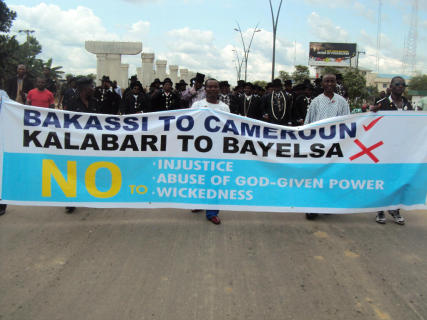
KALABARI NATIONAL FORUM
THE AMAYANABO’S PALACE, BUGUMA.
29th Oct, 2012.
The Director General,
National Boundary Commission
Abuja.
Dear Sir,
PROTEST AGAINST MALICIOUS AND UNCONSTITUTIONAL INTENT TO BALKANIZE AND EXCISE OIL PRODUCING COMMUNITIES IN KALABARI KINGDOM OF RIVERS STATE AND ANNEXING SAME TO BE PART OF BAYELSA STATE.
1.01 INTRODUCTION
We the Traditional and Cultural Rulers, War Canoe Chiefs, Elders, Youth and indeed, the entire good people of Kalabari Kingdom of Rivers State, Nigeria, do humbly and solemnly submit this most significant petition to the authorities of the National Boundary Commission, and by extension to the Rulers of the Country consequent upon its serious constitutional, cultural and security implications.
The plank of this petition is essentially to protest against the malicious, myopic, and selfish interest of certain well placed officials to willfully balkanize and excise virtually all the oil and gas bearing communities of Kalabari Kingdom which include butn not limited to Kula, Soku, Elem-Sangama, Idama and Abissa and all their fishing settlements which from time immemorial have been Kalabari Communities in Rivers State with which they share common linguistic, cultural and ancestral shrines, and also consanguinity.
It is pertinent to mention that the cardinal aim of the design or intent is to excise and seize in perpetuity these Kalabari Communities and making them part of Bayelsa State in order to benefit by design and commission,
the accruals from the oil and gas revenue emanating from these communities and especially those from the SOKU ,ROBERT KIRI, EKULAMA, AND SANTA BARBARA OIL FIELDS which by constitution and historically, are domiciled in Kalabari Territory in Rivers State of Nigeria. This calculated intention has very serious psychological and security implications.
Below, we shall establish the historical antecedents and facts that existed throughout the Colonial Era, and more so, when Bayelsa State was part of the Old Rivers State.
2.00 HISTORICAL & CONSTITUTIONAL FACTS
2.01 The history of boundaries between Rivers and Bayelsa States is traceable to the year 1905 when districts were created by the British colonial government. Degema and Brass districts were distinct districts up until 1914 in the then Calabar Province with clear cut administrative boundaries.
An official map otherwise called the Amory Talbot map was produced in 1935 by Dr Amory Talbot, District Officer of Degema in consultation with the District officer of Brass, Mr. D. O. Simpson determining the boundary between the Nembe and Kalabari Kingdoms as the Santa Barbara River. Please see map Annexure 1. A Public Notice No. 71 issued by the Government of Nigeria (Protectorate and Cameroons) of 1951 describing the boundaries of the Degema Division in the Rivers Province is also attached and marked Annexure 2.
A further settlement in 1954 between the Kula Community (a Kalabari Community) and the Nembe people at the instance of District Officers for Degema (C. L. Barrow) and Brass (J. B. Craig) issued an Administrative Order on 13th May 1954 categorically stating “The Administrative boundary between the Brass and Degema Division and between the Nembe and Kalabari Native Authorities is the Santa Barbara River” please see Annexure 3.
Even further re-alignment in 1947 placing Degema and Brass districts in Rivers Province still maintained the original boundaries between the two.
When Country Councils were created in the then Eastern Region in 1956 the administrative configuration placed all the communities and settlements afore mentioned in the Western group of the Kalabari County Council and the Ijaw County Council, and the boundary still remained, as there was no single community or settlement transferred from one Country Council to the other. Please see Annexure 4 supplement to the Eastern Regional gazette No 37 Vol. 6 dated 18th July, 1957- part B. (E.R.L.N No 143 of 1957). This is the instrument Establishing Local Councils in the Administative Division of DEGEMA. The instrument Amending the instrument Establishing Local Councils within the Area of the Administrative Division of Brass (E.R.L. No 304 of 1959) Annexure 5 is also relevant.
2.02 At the creation of the Old Rivers State on 27th May, 1967 as one of the twelve States of Nigeria, five divisions namely Port Harcourt, Ahoada, Brass, Ogoni and Degema were created (see Annexure 6 – States (Creation and Transitional Provisions) Decree 1967 No 14.
The 1st Military Governor of Rivers State, Commander A.P. Diete Spiff, an illustrious son of Nembe, now Bayelsa State, did not tamper with this delineation. The Degema Division still administered amongst others, all the communities under the defunct Kalabari County Council maintaining its original boundaries with the Brass division.
Subsequent governments and particularly indigenous Governors after the Diete Spiff’s regime namely, Melford Obene Okilo an Ogbia man in present day Bayelsa State, Rufus Ada George an Okrika man in Rivers State, under whose regime Local Government Areas were created never attempted or influenced the transfer of any of the Kalabari communities being referred to i.e Kula, Soku, Elem-Sangama, Idama and Abissa out of the Old Degema division to the Old Brass division.
It is also pertinent to state that an illustrious son of present day Bayelsa State, Prof E.J. Allagoa authored a book “A HISTORY OF THE NIGER DELTA” wherein he expressly described Soku and Elem Sangama as Kalabari communities in the Degema division sharing boundary with Nembe in Brass division. Please see Annexure 7, page 123 and particularly fig. 8 showing a sketch of the Eastern Delta and fringes, as he knew, recognized and acknowledged.
2.03 In December 1991, Ogbia Local Government Area was created out of Brass Local Government Area and Akuku-Toru out of Degema Local Government Area, all in the Old Rivers State. See Annexure 8; Federal Government Gazette No. 84, Vol. 79 of December, 1991. This instrument that created amongst others, these two Local Government Areas, placed (seven) communities namely Abonnema, Kula Soku, Elem-Sangama, Abissa, Idama and Obonoma and its fishing ports and settlements under the administrative control of Akuku Toru Local Government Area.
Again Prof Humphrey Nwosu, Chairman of the defunct National Electoral Commission, stated in a press statement published by the Nigerian Tide Newspaper of 15th September, 1992 (Annexure 9), where he declared that the Ward arrangements in the Country and Rivers State in particular as prescribed by Federal Government Gazette No. 84, Vol. 79 of December, 1991, have not been changed or amended. This declaration clearly left intact the 17 Wards of Akuku – Toru Local Government of which Elem-Sangama, Abissa, Soku and Idama are in Ward 17 and Kula in two Wards of 15 & 16 in Akuku-Toru Local Government Area, Rivers State.
2.04 Historically, the boundary between the New Rivers State and Bayelsa State created out of the Old Rivers State on 1st October, 1996, is the Kalabari’s Western boundary with the Nembe Kingdom along the SANTA BARBARA River and the Eastern boundary along the Engenne River, then South to Idema in Ogbia Local Government Area of Bayelsa State. (ref. Decree No. 36 of 1996 – State Creation, Annexure 10). This terrain, within living memory was and still is habited by the Kalabaris and Akanis (Saka) all in Rivers State. These clan boundaries naturally and automatically serve as the boundary between Rivers State and Bayelsa State. On the Rivers State side the boundaries delineating the old Degema district and on the Bayelsa State side the Old Brass district.
3.00 THE EMERGING DISPUTE
3.01 The boundary between Rivers and Bayelsa States had never been in dispute, see the 10th Edition of the Administrative map marked Annexure 11; until the most unfortunate subterranean manipulations by Bayelsa State which started sometime in 1999, to exert economic control over the oil and gas rich communities within Kalabari territory.
3.02 The 11th Edition of the Administrative map of Nigeria unilaterally produced by the National Boundaries Commission/Federal Surveyor- General’s office in year 2000 but circulated in 2002, inserted material distortions in favour of Bayelsa State even with the pendency of the dispute being addressed by the National Boundary Commission. See Annexure 12.
3.03 This offending map shifted the boundaries between Rivers State and Bayelsa State from the initial boundary between Kalabari and Nembe being West of the SANTA BARBARA RIVER, as acknowledged by all preceding Administrative maps of Nigeria to SAN BARTHOLOMEW River.
3.04 The Rivers State Government vehemently opposed this contraption via a letter dated 20th June, 2002 to the Chairman, National Boundary Commission, His Excellency, Alhaji Atiku Abubakar, Vice President of the Federal Republic of Nigeria (Annexure 13) seeking a total withdrawal of the map from circulation. An important portion of the protest letter states and we quote “…it is very disturbing that the office of the Surveyor General of the Federation which has fully participated at every meeting organized by the National Boundary Commission for the demarcation of the boundary between the two States and which is well aware of the dispute between the two States in this axis, and which is in fact the Team Leader of the joint Field Team can unilaterally produce an Administrative map of Nigeria totally at variance with its last Edition (or in fact any previous edition ever) during the pendency of the dispute…”
3.05 The Director General, National Boundary Commission in his response conveyed in a letter ref. NBC. SEC. 4/S.75 dated 3rd July, 2002 addressed to the Executive Governor of Rivers State (Annexure 14) stated “that I have discussed the issue with the Surveyor General of the Federation and wish to state as follows: that the National Boundary Commission has taken note of the State’s observation on the inadvertent misrepresentation of the Bayelsa/Rivers interstate boundary at the San Bartholomew River as shown on the map. The error was as a result of the delay in inputs from the Rivers State during the production of the Edition and the pressure to quickly publish the long overdue 11th Edition of the Administrative map of Nigeria” . He further assured by stating that “I am to assure Your Excellency that your observations have been noted and that necessary corrections shall be reflected on the 12th Edition currently under production. I am to assure you that the boundary line as reflected on the said Edition of the Administrative map shall in no way have any bearings on the current efforts …”
3.06 Furthermore, it is also worthy of note that the National Boundary Commission in line with its constitutional responsibilities and its continued mediation efforts, commissioned a Well Dichotomy Study in September 2004 undertaken by the Admiralty Consultancy Services UK clearly delineating oil wells and facilities situated in Bayelsa and Rivers States, among others. See Annexure 15.
3.07 This self explanatory effort was perceived to assuage the initial provocation of the Rivers State Government. While Rivers State Government patiently awaited the promised correction of the error laden 11th Edition of the Administrative map of Nigeria, which ordinarily should have redressed the acknowledged fundamental misrepresentations, the Revenue Mobilisation, Allocation and Fiscal Commission surreptitiously released all revenue accruing from Soku Fields and Wells, previously kept in an Escrow Account to Bayelsa State without recourse to Rivers State.
3.08 In spite of every meaningful effort by the Rivers State Government to seek justice in this extremely provocative matter, no progress from the National Boundary Commission has being made to date. It was however rumoured that, the assurances given disappointingly, will not reflect the promised correction but rather that the provisional 12th Administrative map of Nigeria said to be under production will nakedly usurp 80% of Akuku Toru Local Government Area in Rivers State by further shifting the boundary line from SAN BARTHOLOMEW River to SOMBEREIRO River.
3.09 Let us, in the light of the above, state without mincing words, as inhabitants of the area under reference, that this position is totally unacceptable as it is clear manifestation of political manipulation intent on balkanizing Kalabari territory and ceding same to Bayelsa State. This premeditated and strategically executed action is intended to sustain and legitimize the injustice and brazen act of aggression meted out to the Kalabari Kingdom and Rivers State, with the connivance of various Federal Government agencies, under the watchful eyes and supervision of His Excellency, Mr. President, whose home State, most ingloriously, is the direct beneficiary.
This matter we must say, is explosively provocative and has far reaching security implications.
3.10 Let us also state in the strongest terms that our resolve to remain one indivisible Kalabari people with our kit and kin in the old Degema division in the present Rivers State is unshakeable and inalienable.
4.00 RESORT TO LITIGATION
4.01 In clear demonstration of its desire to settle the boundary dispute between Rivers and Bayelsa State, the Government of Rivers State instituted Suit No. SC/106/2009- A-G RIVERS V.A-G BAYELSA STATE & ANOR, as a possible means of ventilating its grievance and giving judicial approval to the Rivers Santa Barbara as the boundary between the two states. As it relates to the clear definition of the boundary between the two states, the relevant reliefs canvassed by the Government of Rivers State at the Supreme Court went as follows:
1). DECLARATION that the purported boundary between the plaintiff state and the 1st Defendant state as shown in the 11th edition of the Administrative Map of Nigeria does not represent the correct boundary between the plaintiff state and 1st Defendant state.
2). DECLARATION that the correct boundary between the plaintiff state and the 1st Defendant is Rivers Santa Barbara.
3). DECLARATION that the 1st Defendant claim to Soku Oil Fields in the Plaintiff’s territorial jurisdiction in false, wrongful, illegal, unconstitutional, vexatious, null and void and of no effect whatsoever.
4). DECLARATION that the Soku Oil Fields/Oil Wells are situated within the territorial boundaries of Rivers State of Nigeria.
4.02 The suit went through the full crucibles of trial, and in a unanimous decision of the Supreme Court delivered on the 10th day of July, 2012, SULEMAN GALADIMA, JSC, reading the lead judgment, observed with emphasis as follows:
“… it is on account of the foregoing and because of the technical nature of the dispute and the claims of the parties the court finds that the NBC as an authority vested with authorities and expertise know-how in dealing with this matter should have once and for all conducted an exhaustive exercise of delineating the disputed boundary. Hence the long-waited 12th edition of the Administrative Map when completed soonest would have been of tremendous assistance in settling this lingering dispute… In the light of the observations I have clearly expressed above I do not feel comfortable to grant the declarations sought until the NBC concludes its exercise of delineation of disputed boundary to finality. It will be futile and premature to determine the boundary of the two parties states in the present circumstances”
4.03 Implicit in the above quoted excerpts of the Supreme Court judgment is the fact that the National Boundary Commission has a duty to delineate the actual boundary between the two states. It is important to emphasize that it was the 11th edition of the Administrative Map of Nigeria that gave rise to all the catalogue of disputes. Therefore, if the Court has pronounced the 11th edition of being bereft of any assistance in the settlement of the dispute, then the only logical conclusion will be for the status quo to be maintained in line with the 10th edition until the 12th edition is produced. This brings to question the justification of the unilateral actions of the Revenue Mobilisation, Allocation and Fiscal Commission and the Office of the Accountant General of the Federation to release all revenue accruing from the SOKU oil wells/fields to Bayelsa State, which hitherto were kept in an Escrow Account, pending the determination of the boundary between the two States on that corridor.
4.04 Again, it will also not conform with logic for such agency like the Revenue Mobilization, Allocation and Fiscal Commission to unilaterally appropriate oil wells and pay accruals of revenue due from Soku, Robert Kiri, Ekulama and Santa-Barbara oil fields to Bayelsa State, as envisaged by the rumoured plan of this Federal Agency, moreso, should the 12th Edition excise 80% of Akulga to Bayelsa State. As a matter of fact, all these oil fields are Kalabari Towns in Akuku-Toru Local Government Area of Rivers State. If any state ought to receive derivation funds from to these oil well, then it must be Rivers State.
4.05 We will reiterate that it is on good authority we gathered very recently, that plans have been perfected by the National Boundary Commission, the Revenue Mobilization, Allocation and Fiscal Commission and the Presidency to extend and further attribute Robert Kiri, Ekulama and San-Barth oil fields to Bayelsa State. This is quite objectionable and shall be highly and vehemently resisted.
5.00 CONCLUSION
5.01 We want to conclude by informing Your Excellency, without any iota of doubt, that we had made great sacrifices in the past to enthrone the peace currently enjoyed by both States in the region. Our patience with and loyalty to the Federal Republic of Nigeria must be protected and seen to be so.
5.02 We therefore UNEQUIVOCALLY, demand that whatever Administrative maps that has been issued that does not reflect the 10th Edition of the administrative map of Nigeria as it affects us, be withdrawn forthwith and status quo maintained as our known historical boundary with the Nembe Kingdom in Bayelsa State is the SANTA BARBARA RIVER.
6.00 PRAYER
6.1 Your Excellency is therefore requested to use Your Excellency’s good offices to advise the parties in the Supreme Court case and the relevant government agencies to await the production of the 12th edition as pronounced by the Supreme Court before taking any further steps, in the interest of peace, equity, fairness and justice.
We remain, Yours faithfully,
HIS ROYAL MAJESTY,
KING (PROF)J. T. J. PRINCEWILL, AMACHREE XI
AMAYANABO OF KALABARI
HRH KING DISRAEL GBOBO BOBMANUEL (2) OWUKORI (1X)
Amayanabo of Abonnema & Chairman, Akulga Council of Traditional Rulers and Chiefs
For: ABONNEMA CITY (COMMUNITY)
CHIEF (DR.) NORMAN TOM IBOROMA (VI), JP
CHAIRMAN, BAKANA COUNCIL OF CHIEFS
HRH KARIBI NANGWO
AMAYANABO OF SOKU
H.R.H. TAMUNOBERE D. ORUSAH (JP)
(AMAYANABO OF ELEM SANGAMA)
H.R.H. KINGDOM G. DATEME (OKIO II)
(AMADABO OF IDAMA)
HRH KING (DR.) S. A. K. D. OFFOIN, XII, JP, GCODA
AMAYANABO OF OFFOIN AMA
CHIEF PRINCE DAVID EMINEYEOLU
SECREATRY, KULA COUNCIL OF CHIEFS
CHIEF TELEMA IMOH
CHAIRMAN, SOKU COUNCIL OF CHIEFS
CHIEF G. N. ALABRABA
Head, Oruwari (Briggs) Group of House.
CHIEF AMBIE MARCUS GEORGEWILL
Head, Otaji (Georgewill) Group of Houses
CHIEF (DR.) O. B. LULU BRIGGS
ALABO T. O . GRAHAM DOUGLAS
CHIEF A. K. HORSFALL
CHIEF (NAVY CAPTAIN RTD) ANGI AJUMOGOBIA
CHIEF FERDINAND NGOGO ANABRABA
ADMIRAL (RTD) ANTHONY BOBMANUEL
COL. HOPE WHYTE (RTD)
PROFESSOR NIMISORE BRIGGS
DR. DAWARI GEORGE
MEMBER, HOUSE OF REPRESENTATIVES
HON. OTELEMA AMACHREE
SPEAKER, RIVERS STATE HOUSE OF ASSEMBLY
HON. TAMMY DANAGOGO
HON. ONARI BROWN
(RVHA, AKULGA 1)
HON. THEODORE GEORGEWILL
CHAIRMAN, AKUKU-TORU LOCAL GOVERNMENT AREA
HON. OJUKAYE FLAG-AMACHREE
CHAIRMAN, ASARI-TORU LOCAL GOVERNMENT AREA
HON. IBIGONI POKIMA
DEGEMA LOCAL GOVERNMENT AREA
HON. (BARR) BENIBO FREDRICK ANABRABA
(RVHA AKULGA 2)
CHIEF SARA IGBE
HON. PAUL AWOYESUKU
ANN KIO BRIGGS
CAPT TAMUNOEMI JAMES
BARR. IBIM DOKUBO
BARR. SAM PHILIP
MR AMAKOAPUYE THOMAS
REV BOMA KALADOKUBO (JP)
ALABO ENGR. E.A. AWOYESUKU JACK
CHIEF KARIBO LORDSON LORD GOGO
Former Pro-Chancellor and Chairman of Council, Federal University, Lokoja, Nigeria. February 2016.
Member, Court of Governors, College of Medicine, University of Lagos, October 2015 for four years.
Copyright © 2025 Prof Nimi Briggs. All rights reserved. Designed by Syllable Media Limited +447869717613